EPOS
EPOS, the European Plate Observing System, is a long-term plan to facilitate the integrated use of data, data products, and facilities from distributed research infrastructures for solid Earth science in Europe.
EPOS will bring together Earth scientists, national research infrastructures, ICT (Information & Communication Technology) experts, decision makers, and the public to develop new concepts and tools for accurate, durable, and sustainable answers to societal questions concerning geo-hazards and those geodynamic phenomena (including geo-resources) relevant to the environment and human welfare.
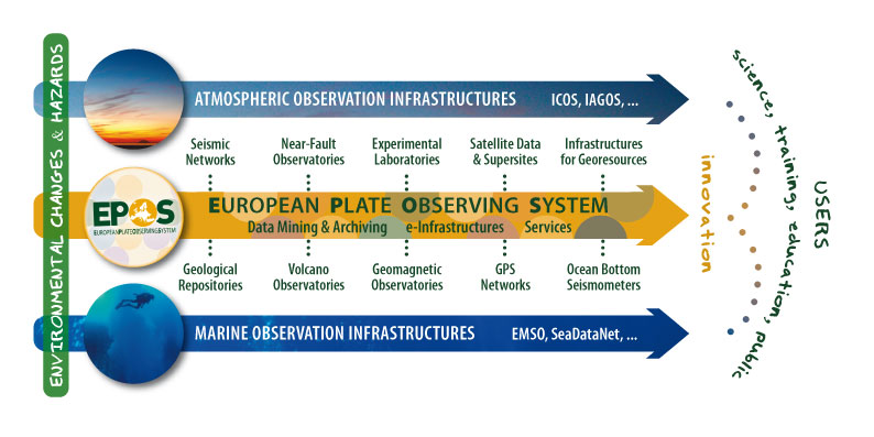
The establishment of EPOS will foster worldwide interoperability in the Earth sciences and services to a broad community of users. EPOS mission is to integrate the diverse and advanced European Research Infrastructures for solid Earth science and build on new e-science opportunities to monitor and understand the dynamic and complex solid-Earth System.
EPOS will identify existing gaps and promote implementation plans with environmental, marine and space science to help solve the grand challenges facing the Earth and its inhabitants. Solid Earth science is concerned with the internal structure and dynamics of planet Earth, from the inner core to the surface. Solid Earth science deals with physical and chemical processes, which cover wide temporal and spatial scales, from microseconds to billions of years and from nanometers to thousands of kilometres.
Geology, natural hazards, natural resources and, in general, environmental processes do not respect national boundaries, therefore seamless, trans-national integration of measurements and data is often vital for optimal research and related activities.
The Earth Science community worldwide has already begun to reap the benefits of integrated accessible data. The study of solid Earth is necessarily multidisciplinary and requires the access to data and products generated by different communities with different data formats and processing procedures.
The understanding of Earth dynamics and tectonic processes relies on the analysis of seismological data, ground deformations inferred from terrestrial and satellite observations, geological and petrochemical studies and laboratory experiments to investigate the chemical and physical processes occurring at depth. In this framework, the next generation of researchers must be able to use multidisciplinary data and prepared to collaborate for cross-disciplinary investigations. This is one of the key challenges for future research in all disciplines.